2025年09月08日 19:38

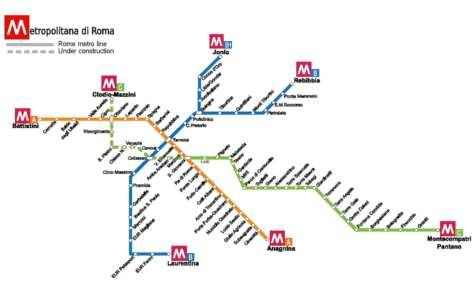
Rome Metro Map
Introduction to the Rome Metro
The Rome Metro is a modern rail system built atop ancient civilization ruins, featuring the A/B/C three-line system that runs beneath the Imperial Forums. It includes the ancient Roman artifact exhibition hall at Termini Hub Station and highlights the high expansion costs due to cultural relic preservation.
Rome Metro Line Overview
Rome Metro Line Information Summary Table
The Rome Metro system currently operates three main lines. Below is a summary table of their detailed information:
| Line | Opening Year | Type | Length (km) | Number of Stations | Start Station | End Station | Passenger Volume |
|---|---|---|---|---|---|---|---|
| Line A (Orange) | 1980 | Heavy Metro | 18.1 | 27 | Battistini | Anagnina | Approx. 170 million/year |
| Line B (Blue) | 1955 | Heavy Metro | 18.9 | 26 | Rebibbia/Jonio | Laurentina | Approx. 130 million/year |
| Line C (Green) | 2014 | Automated Metro | 18.1 | 22 | San Giovanni | Pantano | Approx. 45 million/year |
Additional Notes:
- Lines and Operations
- Line A: Opened on February 16, 1980, connecting northwest and southeast Rome, passing major tourist attractions such as the Vatican and Spanish Steps.
- Line B: Rome's oldest metro line, opened on February 9, 1955. After 1990, it expanded to include the B1 branch (Bologna to Jonio), connecting northeast and south Rome.
- Line C: Rome's newest metro line, with its first section opened on November 9, 2014. It uses fully automated driverless technology and is currently being extended toward the city center.
- System Features and Development
- The Rome Metro is operated by Rome's public transport company (ATAC) and is one of Italy's busiest metro systems, with an annual passenger volume exceeding 350 million.
- System construction faces unique challenges due to Rome's rich underground archaeological heritage, requiring detailed archaeological surveys and preservation efforts for each expansion.
- The fare system uses a flat rate: a single journey costs €1.50, valid for 100 minutes, with transfers between metro and bus systems allowed.
- Transport Connections
- The Rome Metro integrates closely with city buses, trams, and regional rail systems, forming a comprehensive public transport network.
- Major transfer stations include: Termini (intersection of Lines A and B, also Rome's main railway station), San Giovanni (intersection of Lines A and C).
- Airport connection: From Termini Station, take the Leonardo Express train directly to Fiumicino International Airport.
References:
- Rome Public Transport Official Information: ATAC Roma
- Line and Station Details: Rome Metro
- System Operation Status: Metropolitana di Roma
Metro Line Stations and Operating Schedules
The Rome Metro system consists of three main lines. Below is a compilation of station names and detailed operating schedules for each line.
Line A (Orange)
| Station Name | Location Description |
|---|---|
| Battistini | Northwestern terminus, located in the outer area of Rome. |
| Cornelia | Near the northern part of Vatican City, serving residential areas. |
| Baldo degli Ubaldi | Located in the Aurelio district, near commercial areas. |
| Valle Aurelia | Transfer to FL3 regional rail line, connecting to Rome-Viterbo direction. |
| Cipro | Near the Vatican Museums, serving tourist areas. |
| Ottaviano-San Pietro | Main access station for Vatican City, near St. Peter's Square. |
| Lepanto | Located in the Prati district, near the Supreme Court. |
| Flaminio | Near Piazza del Popolo and Villa Borghese, transfer to tram lines. |
| Spagna | Spanish Steps station, Rome's main tourist and shopping area. |
| Barberini | Near Trevi Fountain, serving the central business district. |
| Repubblica | Republic Square station, near the Rome Opera House. |
| Termini | Rome's central railway station, intersection with Line B, major transport hub. |
| Vittorio Emanuele | Located in the Esquilino district, near the historic center. |
| Manzoni | Near the Basilica of St. John Lateran, transfer to tram lines. |
| San Giovanni | Intersection with Line C, near the Basilica of St. John Lateran. |
| Re di Roma | Located in the Appio-Latino district, serving residential areas. |
| Ponte Lungo | Located in the Tuscolano district, near commercial areas. |
| Furio Camillo | Located in the Appio-Latino district, near shopping streets. |
| Colli Albani | Located in the Appio-Tuscolano district, near residential areas. |
| Arco di Travertino | Transfer to multiple bus lines, connecting to suburbs. |
| Porta Furba-Quadraro | Located in southern Tuscolano district, near residential areas. |
| Numidio Quadrato | Located in the Tuscolano district, serving residential areas. |
| Lucio Sestio | Located in the Tuscolano district, near commercial areas. |
| Giulio Agricola | Located in the Tuscolano district, near residential areas. |
| Subaugusta | Near Cinecittà film studios, a cultural attraction. |
| Cinecittà | Location of Italy's famous film studios. |
| Anagnina | Southeastern terminus, with a large park-and-ride facility. |
Operating Schedule
| Direction | First Train | Last Train | Frequency |
|---|---|---|---|
| Battistini → Anagnina | Mon-Thu 5:30 Fri 5:30 Sat 5:30 Sun & holidays 5:30 | Mon-Thu 23:30 Fri 1:30 Sat 1:30 Sun & holidays 23:30 | Peak hours (7:00-9:30, 17:00-20:00): 3-4 minutes Off-peak: 5-7 minutes Evening (after 21:00): 10 minutes |
| Anagnina → Battistini | Mon-Thu 5:30 Fri 5:30 Sat 5:30 Sun & holidays 5:30 | Mon-Thu 23:30 Fri 1:30 Sat 1:30 Sun & holidays 23:30 | Same as above |
Line B (Blue)
| Station Name | Location Description |
|---|---|
| Rebibbia | One of the northeastern termini, near Rebibbia Prison. |
| Ponte Mammolo | Large park-and-ride facility, transfer to long-distance buses. |
| Santa Maria del Soccorso | Located in the Tiburtino district, serving residential areas. |
| Pietralata | Located in the Pietralata district, near residential areas. |
| Monti Tiburtini | Near Sapienza University Medical School and Pertini Hospital. |
| Quintiliani | Located in the Tiburtino district, serving industrial areas. |
| Tiburtina | Rome's second-largest railway station, major transport hub. |
| Bologna | Located in the Nomentano district, branching point for Line B and B1. |
| Policlinico | Near Umberto I University Hospital and Sapienza University. |
| Castro Pretorio | Near the National Library and Sapienza University. |
| Termini | Rome's central railway station, intersection with Line A, major transport hub. |
| Cavour | Near the Roman Forum and Colosseum, tourist area. |
| Colosseo | Colosseum station, major tourist attraction. |
| Circo Massimo | Near the ancient Roman Circus Maximus ruins, tourist area. |
| Piramide | Transfer to Roma-Lido railway line, near Testaccio district. |
| Garbatella | Located in the Ostiense district, near residential areas. |
| Basilica San Paolo | Near St. Paul's Basilica, religious site. |
| Marconi | Located in the Ostiense district, near Roma Tre University. |
| EUR Magliana | Transfer to Roma-Lido railway line, near EUR business district. |
| EUR Palasport | Near sports arena and artificial lake, EUR district. |
| EUR Fermi | Located in the center of EUR district, near Museum of Modern Art. |
| Laurentina | Southern terminus, with a large park-and-ride facility. |
| Jonio | Northern terminus of B1 branch, located in Monte Sacro district. |
| Conca d'Oro | B1 branch station, located in Monte Sacro district. |
| Libia | B1 branch station, located in Trieste district. |
| Sant'Agnese/Annibaliano | B1 branch station, near Sant'Agnese Church. |
Operating Schedule
| Direction | First Train | Last Train | Frequency |
|---|---|---|---|
| Rebibbia/Jonio → Laurentina | Mon-Thu 5:30 Fri 5:30 Sat 5:30 Sun & holidays 5:30 | Mon-Thu 23:30 Fri 1:30 Sat 1:30 Sun & holidays 23:30 | Peak hours (7:00-9:30, 17:00-20:00): 4-5 minutes Off-peak: 6-8 minutes Evening (after 21:00): 10 minutes |
| Laurentina → Rebibbia/Jonio | Mon-Thu 5:30 Fri 5:30 Sat 5:30 Sun & holidays 5:30 | Mon-Thu 23:30 Fri 1:30 Sat 1:30 Sun & holidays 23:30 | Same as above |
Line C (Green)
| Station Name | Location Description |
|---|---|
| San Giovanni | Intersection with Line A, near Basilica of St. John Lateran. |
| Lodi | Located in San Giovanni district, near residential areas. |
| Pigneto | Located in Prenestino-Labicano district, cultural and arts area. |
| Malatesta | Located in Prenestino-Labicano district, near residential areas. |
| Teano | Located in Prenestino-Labicano district, near residential areas. |
| Gardenie | Located in Prenestino-Labicano district, near commercial areas. |
| Mirti | Located in Prenestino-Labicano district, near residential areas. |
| Parco di Centocelle | Near Centocelle Park, leisure area. |
| Torre Spaccata | Located in Torre Spaccata district, near residential areas. |
| Torre Maura | Located in Torre Maura district, near residential areas. |
| Giardinetti | Located in Torre Maura district, near residential areas. |
| Torrenova | Located in Torre Angela district, near residential areas. |
| Torre Angela | Located in Torre Angela district, near commercial areas. |
| Torre Gaia | Located in Torre Gaia district, near residential areas. |
| Grotte Celoni | Located in eastern suburbs of Rome, near residential areas. |
| Due Leoni-Fontana Candida | Located in eastern suburbs of Rome, near residential areas. |
| Borghesiana | Located in Borghesiana district, near residential areas. |
| Bolognetta | Located in eastern suburbs of Rome, near residential areas. |
| Finocchio | Located in Finocchio district, near residential areas. |
| Graniti | Located in eastern suburbs of Rome, near residential areas. |
| Pantano | Eastern terminus, located in the suburbs of Rome. |
Operating Schedule
| Direction | First Train | Last Train | Frequency |
|---|---|---|---|
| San Giovanni → Pantano | Mon-Thu 5:30 Fri 5:30 Sat 5:30 Sun & holidays 5:30 | Mon-Thu 23:30 Fri 1:30 Sat 1:30 Sun & holidays 23:30 | Peak hours (7:00-9:30, 17:00-20:00): 6-7 minutes Off-peak: 8-10 minutes Evening (after 21:00): 12 minutes |
| Pantano → San Giovanni | Mon-Thu 5:30 Fri 5:30 Sat 5:30 Sun & holidays 5:30 | Mon-Thu 23:30 Fri 1:30 Sat 1:30 Sun & holidays 23:30 | Same as above |
Additional Notes
- Line Characteristics
- Line A: Uses MA300 trains, maximum operating speed 90 km/h, average station spacing about 700 meters, Rome's busiest metro line.
- Line B: Uses MB100 trains, maximum operating speed 80 km/h, some sections utilize railway tunnels built in the 1930s.
- Line C: Fully automated driverless technology, uses latest AnsaldoBreda trains, equipped with platform screen doors, improving safety and operational efficiency.
- Service Adjustments
- During special events: Major holidays (e.g., Christmas, New Year) and large events (e.g., football matches, concerts) may extend metro service hours.
- Maintenance periods: On the last Thursday evening of each month, metro service may end early at 21:30 for system maintenance.
- Summer adjustments: During July-August, some lines may reduce frequency, with slightly longer intervals during peak hours.
- Transfers and Connections
- Termini Station: Rome's largest transport hub, transfer to Lines A and B, national rail network, Leonardo Express airport train, and multiple bus lines.
- San Giovanni Station: Intersection of Lines A and C, designed for seamless transfers, with transfer corridors displaying archaeological finds from construction.
- Flaminio Station: Transfer to Roma-Viterbo regional rail line, connecting to northern suburbs of Rome.
- Fares and Ticketing
- Single journey fare €1.50, valid for 100 minutes, allows transfers within metro and bus systems.
- Various passes available: 24-hour ticket (€7), 48-hour ticket (€12.50), 72-hour ticket (€18), weekly ticket (€24).
- All stations have automatic ticket machines accepting cash and cards, major stations have manual ticket counters.
- New electronic payment system launching in 2025, supporting mobile NFC payments and credit card tap-in.
Data Notes
- Station names: Based on official information from Rome's public transport company (ATAC), listed in line order.
- Operating hours: Refer to the latest adjusted schedule for 2025, with extended service until 1:30 AM on Fridays and Saturdays.
- Expansion plans: Line C planned to extend toward city center, connecting Vatican and northern Rome; Line D (Yellow) still in planning stage, will connect EUR district and northern Rome.
For real-time operational information, visit the official website of Rome's public transport company (ATAC Roma ) or use the official mobile app ATAC Roma.
Rome Metro Line Details
Rome Metro Operating Information
- :5:30 - 23:30 (周一至周四),5:30 - 1:30 (周五至周六),5:30 - 23:30 (周日)
- :1.50欧元 (单程票,有效期100分钟)
- :纸质票、电子票、旅游卡
- :
Rome Metro Related Links
Rome Metro Reference Links
Rome Metro Articles
没有新闻
评论
目前还没有评论。