2025年09月08日 19:55
Complete Guide to Singapore MRT System Map
The Singapore Mass Rapid Transit (MRT) system is one of the world's most advanced and efficient public transportation networks, continuously expanding since its inauguration in 1987. This intricate subway network not only connects Singapore's major business districts, residential areas, and tourist attractions but also serves as a lifeline for millions of residents in their daily commutes. Whether you're planning a trip to Singapore or have just moved to this garden city, understanding the MRT system map will greatly facilitate your travel.
Introduction to Singapore MRT
The Singapore MRT system currently consists of six main lines: the North-South Line (NSL), East-West Line (EWL), North-East Line (NEL), Circle Line (CCL), Downtown Line (DTL), and Thomson-East Coast Line (TEL). Each line is color-coded for easy identification on the official map. The MRT network covers the entire island and seamlessly integrates with the Light Rail Transit (LRT) system, forming a comprehensive public transportation network.
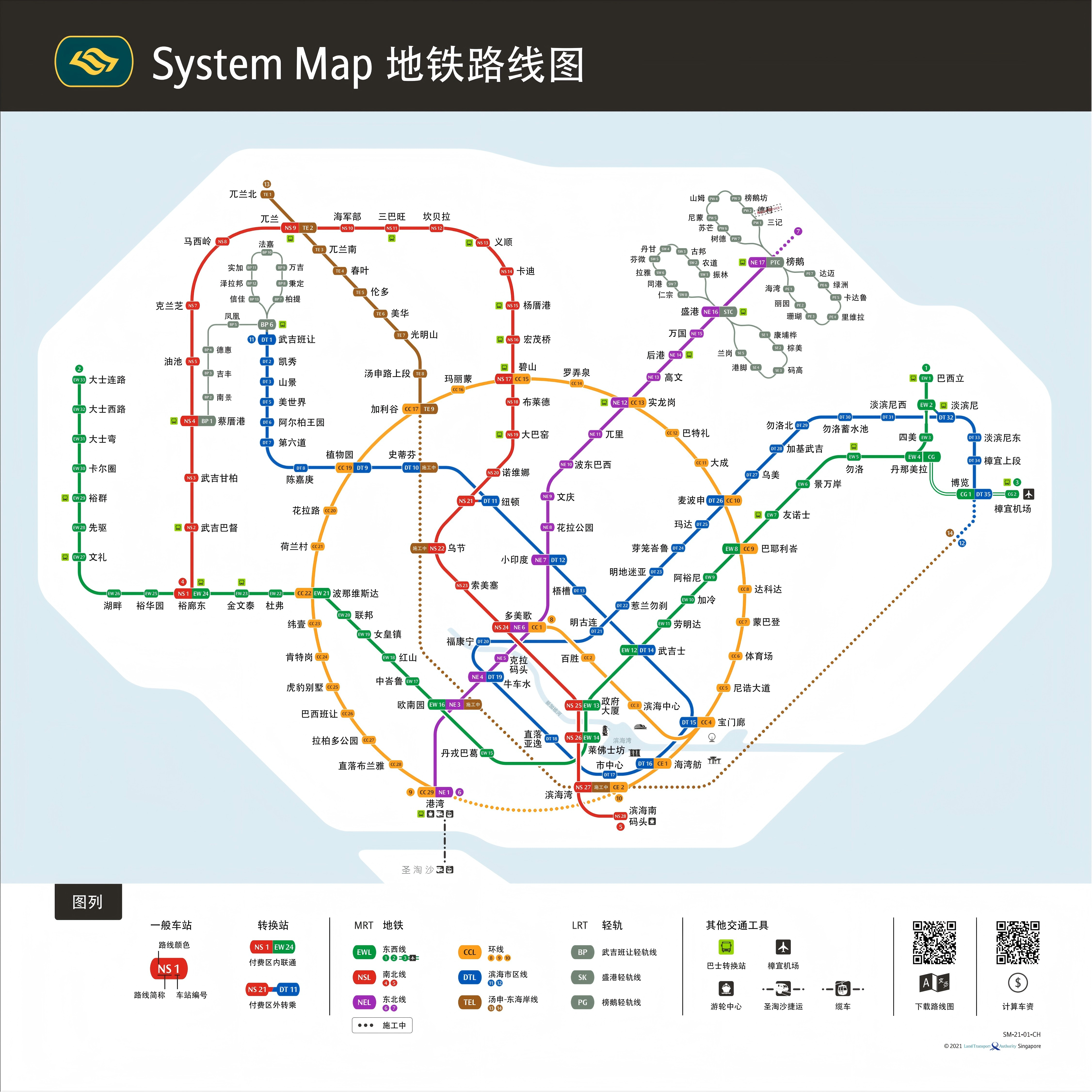
Singapore MRT System Map
Singapore MRT Line Details
Singapore MRT Line Overview
| Line | Year Opened | Type | Length (km) | Stations | Start Station | End Station | Passenger Volume |
|---|---|---|---|---|---|---|---|
| North-South Line (NSL) | 1987 | Heavy Rail | 45 | 27 | Jurong East | Marina South Pier | High |
| East-West Line (EWL) | 1987 | Heavy Rail | 57.2 | 35 | Pasir Ris/Changi Airport | Tuas Link | High |
| North-East Line (NEL) | 2003 | Heavy Rail | 20 | 16 | HarbourFront | Punggol | Medium |
| Circle Line (CCL) | 2009 | Heavy Rail | 35.7 | 31 | Dhoby Ghaut | HarbourFront | Medium |
| Downtown Line (DTL) | 2013 | Heavy Rail | 41.9 | 34 | Bukit Panjang | Expo | Medium |
| Thomson-East Coast Line (TEL) | 2020 | Heavy Rail | 30 (under construction) | 20 (operational) | Woodlands North | Gardens by the Bay | Low |
Detailed Stations and Operating Hours by Line
North-South Line (NSL) Stations and Operating Hours
| Station Name | First Train | Last Train |
|---|---|---|
| Jurong East | 05:30 | 00:15 |
| Bukit Batok | 05:32 | 00:17 |
| Bukit Gombak | 05:35 | 00:20 |
| Choa Chu Kang | 05:38 | 00:23 |
| Yishun | 05:41 | 00:26 |
| Khatib | 05:44 | 00:29 |
| Yio Chu Kang | 05:47 | 00:32 |
| Ang Mo Kio | 05:50 | 00:35 |
| Bishan | 05:53 | 00:38 |
| Braddell | 05:56 | 00:41 |
| Toa Payoh | 05:59 | 00:44 |
| Novena | 06:02 | 00:47 |
| Newton | 06:05 | 00:50 |
| Orchard | 06:08 | 00:53 |
| Somerset | 06:11 | 00:56 |
| Dhoby Ghaut | 06:14 | 00:59 |
| City Hall | 06:17 | 01:02 |
| Raffles Place | 06:20 | 01:05 |
| Marina Bay | 06:23 | 01:08 |
Note: Operating hours may vary on public holidays or during special events. Please refer to official announcements.
East-West Line (EWL) Stations and Operating Hours
| Station Name | First Train | Last Train |
|---|---|---|
| Pasir Ris | 05:30 | 00:15 |
| Tampines | 05:33 | 00:18 |
| Simei | 05:36 | 00:21 |
| Paya Lebar | 05:39 | 00:24 |
| Aljunied | 05:42 | 00:27 |
| Kallang | 05:45 | 00:30 |
| Lavender | 05:48 | 00:33 |
| Bugis | 05:51 | 00:36 |
| City Hall | 05:54 | 00:39 |
| Raffles Place | 05:57 | 00:42 |
| Tanjong Pagar | 06:00 | 00:45 |
| Outram Park | 06:03 | 00:48 |
| Tiong Bahru | 06:06 | 00:51 |
| Redhill | 06:09 | 00:54 |
| Queenstown | 06:12 | 00:57 |
| Commonwealth | 06:15 | 01:00 |
| Jurong East | 06:18 | 01:03 |
Note: The East-West Line splits into two branches: one to Changi Airport and one to Tuas. Please check the official schedule for specific timings.
North-East Line (NEL) Stations and Operating Hours
| Station Name | First Train | Last Train |
|---|---|---|
| HarbourFront | 05:30 | 00:15 |
| Telok Blangah | 05:33 | 00:18 |
| Kent Ridge | 05:36 | 00:21 |
| Haw Par Villa | 05:39 | 00:24 |
| Buona Vista | 05:42 | 00:27 |
| Boon Lay | 05:45 | 00:30 |
| Pioneer | 05:48 | 00:33 |
| Joo Koon | 05:51 | 00:36 |
| Gul Circle | 05:54 | 00:39 |
| Tai Seng | 05:57 | 00:42 |
| Bartley | 06:00 | 00:45 |
| Serangoon | 06:03 | 00:48 |
| Lorong Chuan | 06:06 | 00:51 |
| Bishan | 06:09 | 00:54 |
| Marymount | 06:12 | 00:57 |
| Caldecott | 06:15 | 01:00 |
Circle Line (CCL) Stations and Operating Hours
| Station Name | First Train | Last Train |
|---|---|---|
| Dhoby Ghaut | 05:30 | 00:15 |
| Bras Basah | 05:33 | 00:18 |
| Esplanade | 05:36 | 00:21 |
| Nicoll Highway | 05:39 | 00:24 |
| Stadium | 05:42 | 00:27 |
| Mountbatten | 05:45 | 00:30 |
| Dakota | 05:48 | 00:33 |
| Paya Lebar | 05:51 | 00:36 |
| MacPherson | 05:54 | 00:39 |
| Tai Seng | 05:57 | 00:42 |
| Bartley | 06:00 | 00:45 |
| Serangoon | 06:03 | 00:48 |
| Lorong Chuan | 06:06 | 00:51 |
| Bishan | 06:09 | 00:54 |
| Marymount | 06:12 | 00:57 |
| Caldecott | 06:15 | 01:00 |
Downtown Line (DTL) Stations and Operating Hours
| Station Name | First Train | Last Train |
|---|---|---|
| Bukit Panjang | 05:30 | 00:15 |
| Cashew | 05:33 | 00:18 |
| Hillview | 05:36 | 00:21 |
| Beauty World | 05:39 | 00:24 |
| Sixth Avenue | 05:42 | 00:27 |
| King Albert Park | 05:45 | 00:30 |
| Tan Kah Kee | 05:48 | 00:33 |
| Botanic Gardens | 05:51 | 00:36 |
| Stevens | 05:54 | 00:39 |
| Newton | 05:57 | 00:42 |
| Little India | 06:00 | 00:45 |
| Rochor | 06:03 | 00:48 |
| Bugis | 06:06 | 00:51 |
| Promenade | 06:09 | 00:54 |
| Bayfront | 06:12 | 00:57 |
| Downtown | 06:15 | 01:00 |
Thomson-East Coast Line (TEL) Stations and Operating Hours
| Station Name | First Train | Last Train |
|---|---|---|
| Woodlands North | 05:30 | 00:15 |
| Woodlands | 05:33 | 00:18 |
| Woodlands South | 05:36 | 00:21 |
| Springleaf | 05:39 | 00:24 |
| Lentor | 05:42 | 00:27 |
| Mayflower | 05:45 | 00:30 |
| Bright Hill | 05:48 | 00:33 |
| Upper Thomson | 05:51 | 00:36 |
| Stevens | 05:54 | 00:39 |
| Napier | 05:57 | 00:42 |
| Orchard Boulevard | 06:00 | 00:45 |
| Great World | 06:03 | 00:48 |
| Havelock | 06:06 | 00:51 |
| Outram Park | 06:09 | 00:54 |
| Maxwell | 06:12 | 00:57 |
| Shenton Way | 06:15 | 01:00 |
Singapore MRT Fare Information
Singapore MRT uses a distance-based fare system. Fares are calculated based on travel distance. Standard adult fares are as follows:
- Shortest distance (up to 3.2 km): SGD 0.92
- Average distance (approx. 10 km): SGD 1.79
- Longest distance (over 40 km): SGD 2.27
Additionally, Singapore offers various concession passes:
- Child ticket (under 7 years old): Free
- Student ticket: Concession rates
- Senior citizen ticket (60+ years old): Concession rates
- Tourist pass: 1-day (SGD 10), 2-day (SGD 16), 3-day (SGD 20)
Features of Singapore MRT
The Singapore MRT system is renowned for its excellent service quality and innovative features:
Contactless Smart Ticketing System: Singapore MRT was among the first to adopt EZ-Link cards and contactless payment technology, now supporting various payment methods including bank cards and mobile payments.
Comprehensive Accessibility: All stations are equipped with elevators, ramps, tactile guidance paths, and accessible restrooms for passengers with mobility challenges.
Art and Culture Integration: Many stations feature art installations and cultural displays, such as the "Rain Oculus" at Bayfront Station and murals at Tanjong Pagar Station, offering passengers an artistic experience during their commute.
Environmental Innovation: The MRT system utilizes regenerative braking technology to recover and reuse energy generated during braking, reducing energy consumption.
Safety First: All platforms are equipped with screen doors to prevent accidental falls, along with comprehensive surveillance systems and emergency assistance devices.
Frequently Asked Questions (Q&A)
Q: How do I purchase Singapore MRT tickets? A: You can buy single trip tickets or EZ-Link cards at any station's ticketing machine. Single trip tickets are suitable for short-term visitors, while EZ-Link cards offer discounted fares for longer stays.
Q: What is the frequency of Singapore MRT trains? A: During peak hours (weekdays 7-9 AM and 5-8 PM), trains run every 2-3 minutes; during off-peak hours, every 5-7 minutes.
Q: Are there other public transport options after the last MRT train? A: Yes, Singapore has an extensive night bus service (Night Rider and Nite Owl) operating until 4 AM, covering major residential and entertainment areas.
Q: Can I bring bicycles on the MRT? A: Yes, but only during off-peak hours (weekdays excluding 7:00-9:00 and 17:00-20:00, and all day on weekends and public holidays), and a bicycle ticket must be purchased.
Q: Is eating and drinking allowed on the MRT? A: No. Eating and drinking, including water and snacks, are strictly prohibited in Singapore MRT, with fines for violations.
Q: How can I get the latest MRT map? A: You can obtain free paper maps at any station or download the digital version via the official "MyTransport" mobile app.
The Singapore MRT system is not just a mode of transportation but also a symbol of the city's modernity and efficiency. Whether you're commuting to work or exploring the city, the MRT offers a comfortable and convenient travel experience. Remember to download the official app to check train arrival times and route information, making your Singapore journey smoother and more enjoyable.
Singapore MRT Operating Information
- Operating Hours:5:30 AM - 12:00 AM (Monday to Saturday), 6:00 AM - 12:00 AM (Sundays and holidays)
- Fare:SGD 0.90-2.50 (based on distance)
- Payment Methods:EZ-Link card, NETS FlashPay card, Singapore Tourist Pass
- Official Website:
Singapore MRT Related Links
Singapore MRT Reference Links
Singapore MRT Articles
No News
评论
目前还没有评论。