2025年09月08日 19:42
Amsterdam Metro Guide: Routes, Fares, and Features
Explore the efficient transportation network of the Dutch capital—the Amsterdam Metro system. This article provides a detailed introduction to the operating lines, station information, fare ranges, and unique features of the Amsterdam Metro, making it easy for both tourists and local residents to grasp the essentials of travel.
Introduction to the Amsterdam Metro
The Amsterdam Metro system began operations in 1977 and has since developed into a vital part of the city's public transportation network. It currently consists of 5 main lines, covering the city center and key surrounding areas, serving hundreds of thousands of passengers daily. The metro not only connects Amsterdam Central Station with the southern, eastern, and western suburbs but also seamlessly integrates with the city's trams, buses, and regional trains, forming an efficient transportation network.
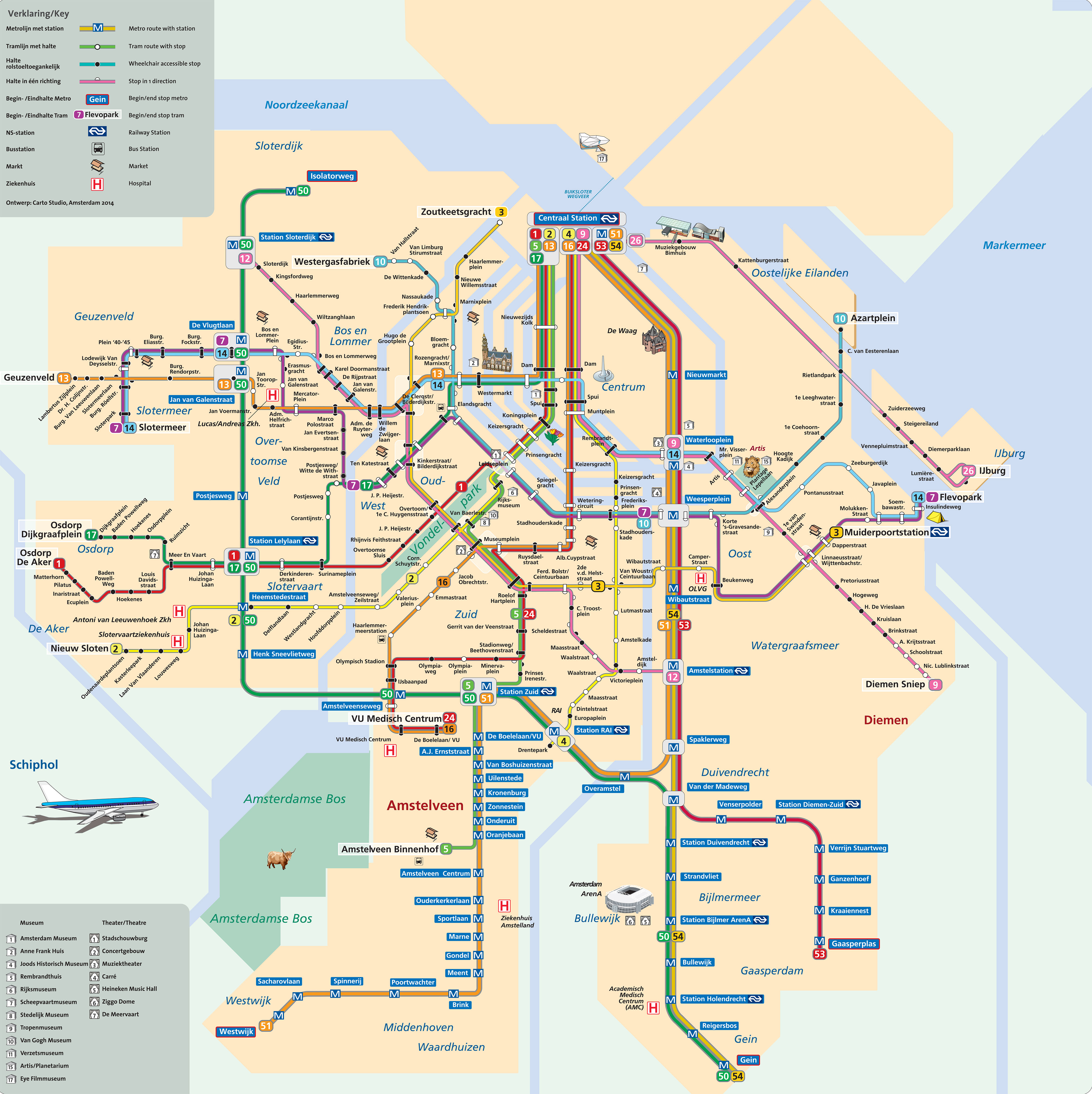
Amsterdam Metro Map
Amsterdam Metro Line Details
Amsterdam Metro Line Overview
| Line | Year Opened | Type | Length (km) | Number of Stations | Starting Station | Ending Station | Daily Ridership (approx.) |
|---|---|---|---|---|---|---|---|
| 50 (Ring) | 1997 | Metro | 20.5 | 20 | Isolatorweg | Gein | 150,000 |
| 51 | 1990 | Metro/Light Rail | 19.5 | 29 | Centraal Station | Westwijk/Isolatorweg | 120,000 |
| 52 (North-South) | 2018 | Fully Automated | 9.7 | 8 | Noord | Zuid | 80,000 |
| 53 | 1997 | Metro | 18.0 | 14 | Centraal Station | Gaasperplas | 100,000 |
| 54 | 1997 | Metro | 17.0 | 15 | Centraal Station | Gein | 110,000 |
Station and Schedule Details by Line
Metro Line 50 (Ring Line)
| Station Name | First Train | Last Train |
|---|---|---|
| Isolatorweg | 06:00 | 00:30 |
| Sloterdijk | 06:02 | 00:32 |
| ...(intermediate stations) | ... | ... |
| Gein | 06:40 | 01:10 |
Note: Line 50 operates at 5-minute intervals during weekday peak hours, 10 minutes during off-peak hours, and 10-15 minutes on weekends.
Metro Line 51
| Station Name | First Train | Last Train |
|---|---|---|
| Centraal Station | 06:00 | 00:30 |
| Nieuwmarkt | 06:02 | 00:32 |
| ...(intermediate stations) | ... | ... |
| Westwijk | 06:45 | 01:15 |
Note: Line 51 splits into two branches—one to Westwijk and one to Isolatorweg. Please check the destination display.
Metro Line 52 (North-South Line)
| Station Name | First Train | Last Train |
|---|---|---|
| Noord | 06:00 | 00:30 |
| Noorderpark | 06:02 | 00:32 |
| ...(intermediate stations) | ... | ... |
| Zuid | 06:15 | 00:45 |
Note: Line 52 is fully automated and driverless, connecting Amsterdam North with the southern business district.
Metro Line 53
| Station Name | First Train | Last Train |
|---|---|---|
| Centraal Station | 06:00 | 00:30 |
| Wibautstraat | 06:02 | 00:32 |
| ...(intermediate stations) | ... | ... |
| Gaasperplas | 06:35 | 01:05 |
Metro Line 54
| Station Name | First Train | Last Train |
|---|---|---|
| Centraal Station | 06:00 | 00:30 |
| Wibautstraat | 06:02 | 00:32 |
| ...(intermediate stations) | ... | ... |
| Gein | 06:38 | 01:08 |
Note: Last train times refer to departures from the starting station. Times may vary slightly at intermediate stations.
Fare Information
The Amsterdam Metro uses a unified fare system by GVB, shared with trams and buses:
- Single ticket: Valid for 1 hour, €3.20
- Day pass: Options for 1/2/3/7 days, ranging from €8.50 to €41.00
- Anonymous OV-chipkaart: Issuance fee €7.50, distance-based fares
- Personal OV-chipkaart: Discounts available, ideal for frequent travelers
- Children: Discounts for ages 4-11, free for under 4
Tourists are advised to choose day or multi-day passes for better value. All tickets can be purchased at station ticket machines, GVB service points, or online.
Metro Features
The Amsterdam Metro system offers several unique features:
- Underwater Tunnel Experience: Line 52 passes through a tunnel under the IJ River, offering a unique underwater journey.
- Art Stations: Several stations feature public art, such as light installations at Noord station and architectural designs at Station Zuid.
- Eco-Friendly Operation: Since 2018, all metro trains run on electricity generated by Dutch wind power.
- Accessibility: All stations are equipped with elevators, escalators, and tactile paving for people with reduced mobility.
- Smart Scheduling: Tight integration with other public transport minimizes transfer waiting times.
Frequently Asked Questions (Q&A)
Q: What are the operating hours of the Amsterdam Metro? A: The metro generally operates from 6:00 AM to around 12:30 AM, with extended hours until 1:30 AM on Friday and Saturday nights for some lines. Specific times vary by line; check real-time schedules before travel.
Q: Are bicycles allowed on the metro? A: Bicycles are not allowed during peak hours on weekdays (7:00-9:00 AM and 4:00-6:30 PM). At other times, they are permitted with a bicycle ticket (€4.50).
Q: How can I get the best value metro ticket? A: If you plan to stay in Amsterdam for several days and use public transport frequently, consider a multi-day pass (e.g., 3-day pass for €21.00) or an anonymous OV-chipkaart with top-up as needed.
Q: Does the metro operate overnight? A: The Amsterdam Metro does not provide 24-hour service, but some lines have extended hours on Friday and Saturday nights. Night buses are available for late-night travel.
Q: Is Wi-Fi available on the metro? A: Yes, free Wi-Fi is available in all metro stations and trains. Connect to "GVB Free Wi-Fi" to use the service.
Q: What should I do in an emergency? A: Each train car has an emergency intercom to contact the driver directly. Emergency buttons and security cameras are also installed in stations and trains for passenger safety.
The Amsterdam Metro system is a key choice for urban travel due to its efficiency, cleanliness, and reliability. Whether commuting or sightseeing, the metro offers a quick way to reach your destination while experiencing the convenience and comfort of this modern city.
Amsterdam Metro Operating Information
- Operating Hours:6:00 AM - 12:30 AM (Monday to Friday), 6:00 AM - 1:00 AM (Saturday), 7:00 AM - 12:30 AM (Sunday)
- Fare:From €3.20 (based on zones)
- Payment Methods:OV-chipkaart, disposable tickets
- Official Website:
Related Links for Amsterdam Metro
Amsterdam Metro Reference Links
Amsterdam Metro Articles
No News
评论
目前还没有评论。