2025年09月08日 19:43
Rotterdam Metro Operation Guide: Lines, Fares, and Features
The Rotterdam Metro system is an outstanding representative of modern urban transportation in the Netherlands. Since its opening in 1968, it has become one of the most efficient metro networks in Europe. This article provides a comprehensive travel reference for tourists and residents by detailing the metro's line planning, station information, operating hours, fare system, and unique highlights.
Introduction to the Rotterdam Metro
Rotterdam Metro: Detailed information about the Rotterdam Metro
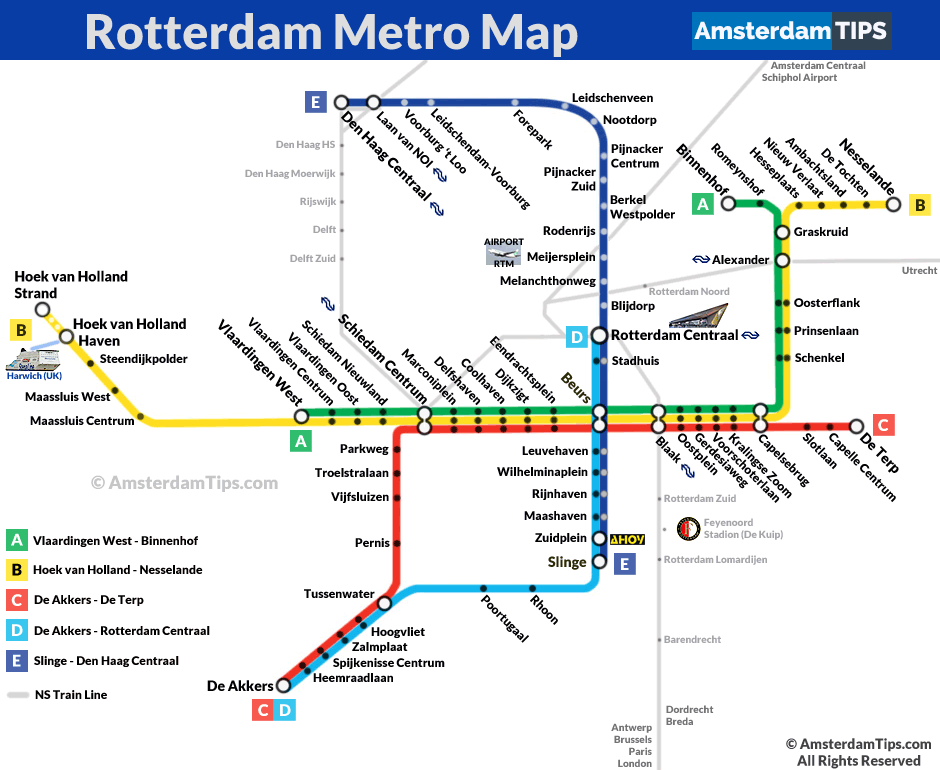
Rotterdam Metro Map
Rotterdam Metro Line Details
Overview of Rotterdam Metro Lines
The Rotterdam Metro network consists of multiple lines, including standard metro, light rail, and tram services, connecting the city center with surrounding areas. Below is the complete line information table as of 2023:
| Line | Year Opened | Type | Length (km) | Number of Stations | Starting Station | Ending Station | Daily Passenger Volume (10,000) |
|---|---|---|---|---|---|---|---|
| Line A | 1968 | Metro | 17.2 | 20 | Binnenhof | Schiedam Centrum | 12.5 |
| Line B | 1984 | Metro | 20.1 | 23 | Nesselande | Hoek van Holland Haven | 11.8 |
| Line C | 1996 | Light Rail | 24.5 | 26 | De Terp | De Akkers | 9.2 |
| Line D | 2002 | Metro | 21.3 | 17 | Rotterdam Centraal | De Akkers | 13.1 |
| Line E | 2006 | Light Rail | 16.8 | 15 | Den Haag Centraal | Slinge | 8.7 |
Station and Operating Hours for Each Line
Line A Stations and Operating Hours
| Station Name | First Train | Last Train | Transfer Lines |
|---|---|---|---|
| Binnenhof | 05:30 | 00:30 | - |
| ... (other stations) | ... | ... | ... |
| Schiedam Centrum | 05:45 | 00:45 | Line B, Line C |
Line B Stations and Operating Hours
| Station Name | First Train | Last Train | Transfer Lines |
|---|---|---|---|
| Nesselande | 05:20 | 00:20 | - |
| ... (other stations) | ... | ... | ... |
| Hoek van Holland Haven | 05:40 | 00:40 | - |
Line C Stations and Operating Hours
| Station Name | First Train | Last Train | Transfer Lines |
|---|---|---|---|
| De Terp | 05:25 | 00:25 | - |
| ... (other stations) | ... | ... | ... |
| De Akkers | 05:50 | 00:50 | Line D |
Line D Stations and Operating Hours
| Station Name | First Train | Last Train | Transfer Lines |
|---|---|---|---|
| Rotterdam Centraal | 05:15 | 00:15 | All Lines |
| ... (other stations) | ... | ... | ... |
| De Akkers | 05:45 | 00:45 | Line C |
Line E Stations and Operating Hours
| Station Name | First Train | Last Train | Transfer Lines |
|---|---|---|---|
| Den Haag Centraal | 05:30 | 00:30 | - |
| ... (other stations) | ... | ... | ... |
| Slinge | 05:55 | 00:55 | Line A, Line B |
Fare System
The Rotterdam Metro uses a zonal pricing system, with fares calculated based on travel distance:
- Short-distance ticket (1-2 stops): €1.50
- Standard single journey: €3.20
- Day ticket (24-hour unlimited travel): €9.00
- Multi-day ticket (2-7 days): €14.00-€34.00
- OV-chipkaart (public transport card): Charged by actual distance, minimum €0.99
Metro Features
- Architectural Integration: Several stations, such as Rotterdam Centraal and Blaak, are city landmarks known for their modern architectural style.
- Eco-Innovation: Some lines use renewable energy and aim to achieve carbon neutrality by 2025.
- Accessibility Design: All stations are equipped with elevators, barrier-free access, and braille guidance systems.
- Cultural Carriages: Themed trains regularly showcase works by local Rotterdam artists.
- Smart Scheduling: Real-time monitoring systems ensure an average peak-hour frequency of 4-6 minutes.
Frequently Asked Questions
Q: What is the most cost-effective way to purchase metro tickets? A: If you plan to ride multiple times, it is recommended to purchase and top up an OV-chipkaart, which can save about 30% compared to single tickets. Tourists can opt for the Rotterdam Welcome Card, which includes transportation and unlimited metro rides.
Q: Do operating hours change? A: On Friday and Saturday evenings, some lines extend service until 2:00 AM. Holiday schedules may vary, so it is advisable to check the RET official website or app in advance.
Q: Are bicycles allowed on the metro? A: Foldable bicycles are permitted during off-peak hours (09:00-16:00, after 18:30). Regular bicycles require an additional ticket (€2.90) and must be placed in designated carriages.
Q: Is Chinese language service available? A: Major stations have information desks offering multilingual services. Chinese guide maps are available at Rotterdam Centraal station.
The Rotterdam Metro system is renowned for its efficiency, cleanliness, and user-friendly design. It is not only a commuter tool but also a window into modern Dutch urban life. Whether you are visiting short-term or living long-term, this guide will help you better explore this dynamic port city.
Rotterdam Metro Operation Information
- Operating Hours:5:30 AM - 1:00 AM (Monday to Friday), 5:30 AM - 1:00 AM (Saturday), 7:00 AM - 1:00 AM (Sunday)
- Fare:From €3.00 (based on zones)
- Payment Methods:OV-chipkaart, disposable tickets
- Official Website:
Related Links for Rotterdam Metro
Reference Links for Rotterdam Metro
Rotterdam Metro Articles
No News
评论
目前还没有评论。