2025年09月02日 16:49
Nagoya Municipal Subway System (Nagoya City Subway)
The Nagoya Municipal Subway is the largest subway system in the Chubu region, connecting various key areas of Nagoya City.
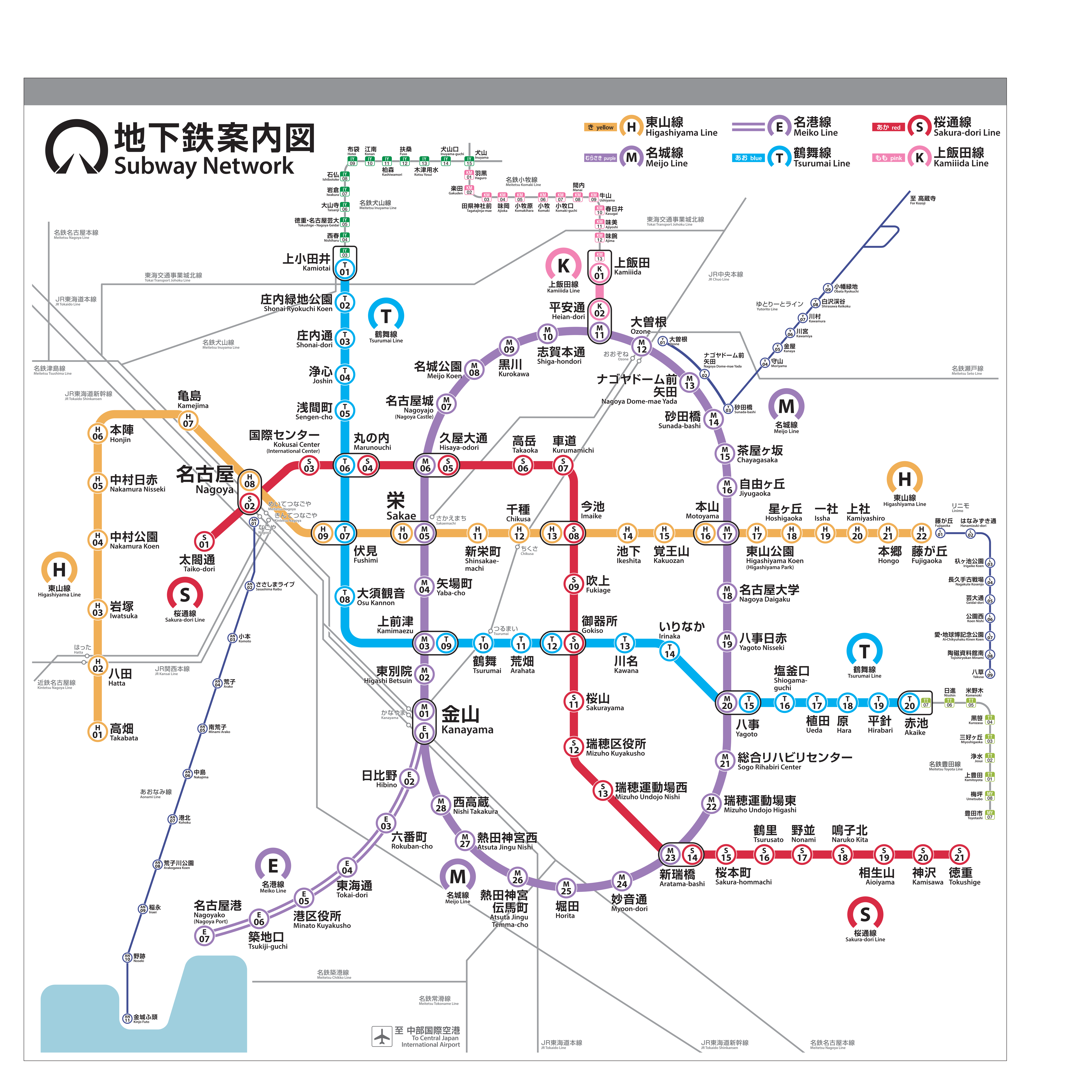
Nagoya Subway Map
Details of Nagoya Subway Lines
Overview of Subway Lines
| Line Name | Opening Year | Type | Length (km) | Number of Stations | Starting Station | Terminating Station | Daily Ridership |
|---|---|---|---|---|---|---|---|
| Higashiyama Line | 1957 | Subway | 20.6 | 22 | Takahata | Fujigaoka | 450,000 |
| Meijo Line | 1965 | Subway | 26.4 | 28 | Loop Line | Loop Line | 280,000 |
| Meikō Line | 1971 | Subway | 15.6 | 16 | Kanayama | Nagoya Port | 85,000 |
| Tsurumai Line | 1977 | Subway | 23.8 | 20 | Kamioda | Akaike | 180,000 |
| Sakuradōri Line | 1989 | Subway | 14.8 | 14 | Nakamura Ward Office | Tokushige | 150,000 |
| Kamiiida Line | 2003 | Subway | 0.8 | 2 | Heian-dōri | Kamiiida | 25,000 |
Higashiyama Line Stations and Operating Hours
| Station Name | First Train | Last Train | Remarks |
|---|---|---|---|
| Takahata | 5:30 AM | 12:00 AM | Western terminal |
| Hatta | 5:32 AM | 11:58 PM | |
| Iwatsuka | 5:34 AM | 11:56 PM | |
| Nakamura Park | 5:36 AM | 11:54 PM | |
| Nakamura Nikkaido | 5:38 AM | 11:52 PM | Red Cross Hospital |
| Honjin | 5:40 AM | 11:50 PM | |
| Kamejima | 5:42 AM | 11:48 PM | |
| Nagoya | 5:44 AM | 11:46 PM | JR Nagoya Station |
| Fushimi | 5:46 AM | 11:44 PM | City center |
| Sakae | 5:48 AM | 11:42 PM | Downtown area |
| Shinaoecho | 5:50 AM | 11:40 PM | |
| Chikusa | 5:52 AM | 11:38 PM | JR Chikusa Station |
| Imazu | 5:54 AM | 11:36 PM | |
| Ikesita | 5:56 AM | 11:34 PM | |
| Kakuōzan | 5:58 AM | 11:32 PM | |
| Motoyama | 6:00 AM | 11:30 PM | |
| Higashiyama Park | 6:02 AM | 11:28 PM | Higashiyama Zoo and Botanical Garden |
| Hoshigaoka | 6:04 AM | 11:26 PM | |
| Ichisha | 6:06 AM | 11:24 PM | |
| Kamisha | 6:08 AM | 11:22 PM | |
| Hongo | 6:10 AM | 11:20 PM | |
| Fujigaoka | 6:12 AM | 11:18 PM | Eastern terminal |
Meijo Line Stations and Operating Hours
| Station Name | First Train | Last Train | Remarks |
|---|---|---|---|
| Sakae | 5:30 AM | 12:00 AM | Downtown area |
| Yabacho | 5:32 AM | 11:58 PM | |
| Kamimaezu | 5:34 AM | 11:56 PM | |
| Higashibetsuin | 5:36 AM | 11:54 PM | |
| Kanayama | 5:38 AM | 11:52 PM | JR Kanayama Station |
| Hibino | 5:40 AM | 11:50 PM | |
| Rokubancho | 5:42 AM | 11:48 PM | |
| Tokai-dōri | 5:44 AM | 11:46 PM | |
| Minato Ward Office | 5:46 AM | 11:44 PM | Minato Ward Government Office |
| Tsukijiguchi | 5:48 AM | 11:42 PM | |
| Nagoya Port | 5:50 AM | 11:40 PM | Nagoya Port |
| Nishi Takakura | 5:52 AM | 11:38 PM | |
| Jingu Nishi | 5:54 AM | 11:36 PM | |
| Denmacho | 5:56 AM | 11:34 PM | |
| Atsuta Shrine Denmacho | 5:58 AM | 11:32 PM | Atsuta Shrine |
| Atsuta Shrine Nishi | 6:00 AM | 11:30 PM | |
| Myōon-dōri | 6:02 AM | 11:28 PM | |
| Hotta | 6:04 AM | 11:26 PM | |
| Shinyurakucho | 6:06 AM | 11:24 PM | |
| Mizuho Ward Office | 6:08 AM | 11:22 PM | Mizuho Ward Government Office |
| Mizuho Sports Park East | 6:10 AM | 11:20 PM | Sports stadium |
| Nagoya University | 6:12 AM | 11:18 PM | Nagoya University |
| Motoyama | 6:14 AM | 11:16 PM | |
| Jiyugaoka | 6:16 AM | 11:14 PM | |
| Chayamachi | 6:18 AM | 11:12 PM | |
| Sunadabashi | 6:20 AM | 11:10 PM | |
| Osone | 6:22 AM | 11:08 PM | |
| Heian-dōri | 6:24 AM | 11:06 PM | |
| Shigahon-dōri | 6:26 AM | 11:04 PM | |
| Kurokawa | 6:28 AM | 11:02 PM | |
| Meijo Park | 6:30 AM | 11:00 PM | Meijo Park |
| City Hall (Shiyakusho) | 6:32 AM | 10:58 PM | Nagoya City Hall |
| Hisaya-odori | 6:34 AM | 10:56 PM |
Sakuradōri Line Stations and Operating Hours
| Station Name | First Train | Last Train | Remarks |
|---|---|---|---|
| Nakamura Ward Office | 5:30 AM | 12:00 AM | Western terminal |
| Nagoya | 5:33 AM | 11:57 PM | JR Nagoya Station |
| International Center | 5:36 AM | 11:54 PM | |
| Marunouchi | 5:39 AM | 11:51 PM | |
| Hisaya-odori | 5:42 AM | 11:48 PM | |
| Takatake | 5:45 AM | 11:45 PM | |
| Shadō | 5:48 AM | 11:42 PM | |
| Imazu | 5:51 AM | 11:39 PM | |
| Fukiage | 5:54 AM | 11:36 PM | |
| Okidosho | 5:57 AM | 11:33 PM | |
| Sakurayama | 6:00 AM | 11:30 PM | |
| Mizuho Ward Office | 6:03 AM | 11:27 PM | Mizuho Ward Government Office |
| Shinyurakucho | 6:06 AM | 11:24 PM | |
| Tokushige | 6:09 AM | 11:21 PM | Eastern terminal |
Nagoya Subway Operating Information
- Operating Hours:5:30 AM - 12:30 AM (may vary by line)
- Fare:¥200-360 for single journeys based on distance
- Payment Methods:IC cards (Manaca, TOICA, Suica), paper tickets, one-day passes
- Official Website:
Nagoya Subway Related Links
Nagoya Subway Reference Links
评论
目前还没有评论。