2025年07月25日 14:12

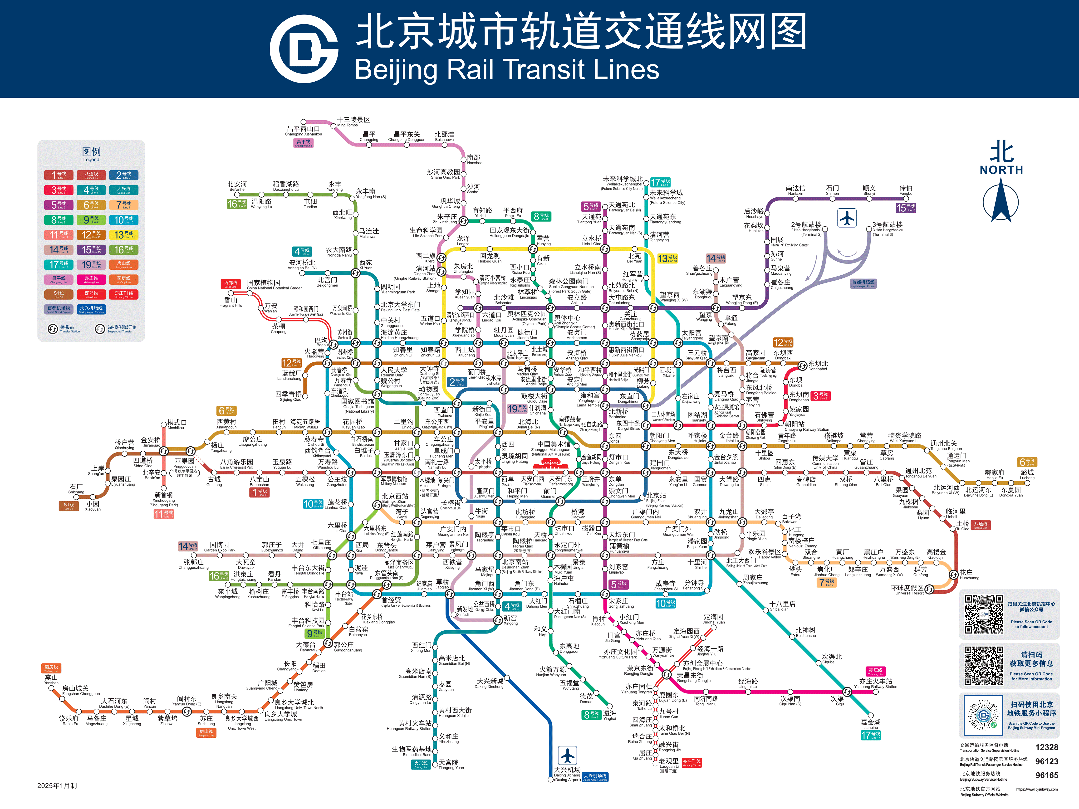
beijing Metro
beijing Metro Map Info
beijingmetro:Detailed information about beijing metro
beijing Metro Line Map
beijing Metro Line Details
beijing Metro Operating Information
- :5:00 AM - 11:00 PM (may vary by line)
- :3-9 yuan (based on distance)
- :Single-journey ticket, Beijing Transportation Card, mobile payment
- :
beijing Metro Related Link
- Beijing Metro Map
- Changchun Metro Map
- Changsha Metro Map
- Chengdu Metro Map
- Chongqing Metro Map
- Dalian Metro Map
- Dongguan Metro Map
- Fuzhou Metro Map
- Guangzhou Metro Map
- Guiyang Metro Map
- Hangzhou Metro Map
- Haerbin Metro Map
- Hefei Metro Map
- Hongkong Metro Map
- Jinan Metro Map
- Kunming Metro Map
- Nanchang Metro Map
- Nanjing Metro Map
- Nanning Metro Map
- Ningbo Metro Map
- Qingdao Metro Map
- Shanghai Metro Map
- Shenyang Metro Map
- Shenzhen Metro Map
- Shijiazhuang Metro Map
- Suzhou Metro Map
- Tianjin Metro Map
- Wulumuqi Metro Map
- Wenzhou Metro Map
- Wuhan Metro Map
- Wuxi Metro Map
- Xiamen Metro Map
- Xian Metro Map
- Zhengzhou Metro Map
- Nantong Metro Map
- Aomen Metro Map
- Changzhou Metro Map
- Chuzhou Metro Map
- Ezhou Metro Map
- Foshan Metro Map
- Huhehaote Metro Map
- Jinhua Metro Map
- Lanzhou Metro Map
- Luoyang Metro Map
- Qingyuan Metro Map
- Shaoxing Metro Map
- Taiyuan Metro Map
- Taizhou Metro Map
- Wuhu Metro Map
- Xiangtan Metro Map
- Xiangxi Metro Map
- Xuchang Metro Map
- Xuzhou Metro Map
- Ziyang Metro Map
beijing Metro Reference Link
beijing Metro Posts
地铁直达,北京海淀这座科技园完成竣工备案,预计明年全面开园
2025年12月04日 10:08
0
腾
北京城南从发展洼地蝶变为新增长极
腾讯网2025年12月04日 10:07腾讯网
0
北
“湾里号”主题地铁列车投入运营
北京日报 on MSN2025年12月04日 10:07北京日报 on MSN
0
腾
北京最大奥莱月底在副中心开业!特色地铁列车直达——
腾讯网2025年12月04日 10:07腾讯网
0
北
特色地铁直达 北京最大奥莱年底开业|新商圈新潮流
北青网 on MSN2025年12月04日 10:07北青网 on MSN
0
腾
“湾里”特色地铁列车开行!市民可直达北京最大奥莱
腾讯网2025年12月04日 10:07腾讯网
0
北
9分钟到北京!北京地铁要通到河北了!
北京日报 on MSN2025年12月04日 10:07北京日报 on MSN
0
腾
副中心⇋廊坊,9分钟!地铁平谷线最新进展
腾讯网2025年12月04日 10:07腾讯网
0
廊
大厂再添一条直通北京地铁的公交线
廊坊传媒网2025年12月04日 10:07廊坊传媒网
0
北
北京地铁线上的千年站名
北京日报 on MSN2025年12月03日 10:04北京日报 on MSN
0
腾
北京再有地铁即将开工,未来将与M101线实现互联互通
腾讯网2025年12月03日 10:04腾讯网
0
人
“湾里号”主题地铁列车投入运营
人民网 on MSN2025年12月03日 10:04人民网 on MSN
0
北
北京地铁13座车辆基地上新智能360°全景检测系统
北青网 on MSN2025年12月03日 10:03北青网 on MSN
0
京
好消息!北京地铁14号线阜通站B2口本周六开通
京报网 on MSN2025年12月03日 10:03京报网 on MSN
0
北
9分钟到北京!当河北迎来北京地铁
北青网 on MSN2025年12月03日 10:01北青网 on MSN
0
腾
五年来北京开通19条(段)180公里地铁新线
腾讯网2025年12月03日 10:00腾讯网
0
京
北京地铁“热血专列”上线
京报网 on MSN2025年12月03日 10:00京报网 on MSN
0
房
南沙有轨电车十年规划终迎转机,湾区门户交通升级在望
房天下新闻2025年12月02日 10:10房天下新闻
0
新
过去五年北京开通19条(段)地铁新线,城轨运营总里程全国第一
新京报 on MSN2025年12月02日 10:08新京报 on MSN
0
原创 中转不是“路过”,北京如何成国际旅客“第一选择”?答案很简单
2025年12月02日 10:08
0
评论
目前还没有评论。